The following article from John's June 2012 Controllers Corner again addresses the issue of the distance between controls. It makes reference to a real life issue from the Easter 2012 3 Days which shows how easily problems can occur. Given the rules I feel the approach of the organisers could be contentious - what do you think?
John writes: It seems timely to again make mention of control sites and how close they can be placed to each other.
Those who competed in the (2012) Australian 3 Day over Easter are probably aware that this became an issue on Day 2 of the competition. There were two (alternative) last controls, and quite a few competitors became confused between the two, and a number of mis-punches were recorded.
My understanding is that most of these were eventually reinstated, although the procedure was a bit “messy” given that no formal complaint or subsequent protest was lodged on the day. However organisers were prepared to consider a late approach on the following day.
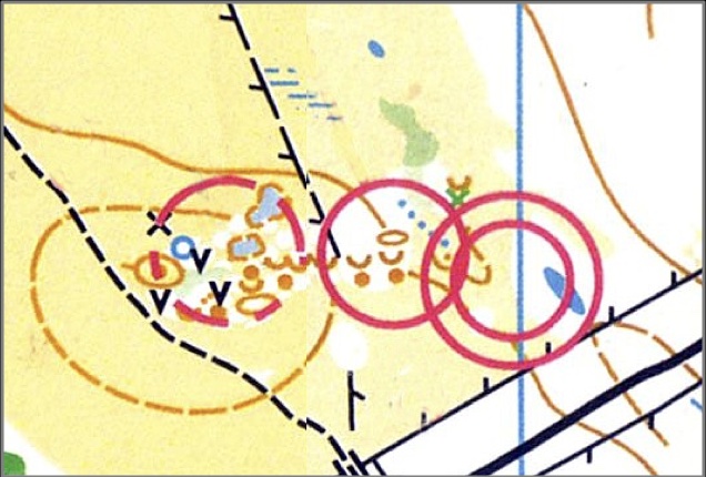
The two somewhat confusing controls (both approached roughly from the north west) are shown below (I’ve managed to photo-shop them both onto the one map). A was described as the SW pond on the NW edge. B was described as the Eastern depression.
The rules state that (Editors note: these are the current rules)
19.4 Controls (including the start control flag) must not be sited within 30 metres of each other. For Sprint (including Sprint Relay and Knock-Out Sprint), this may be reduced as follows. For map scales 1:4000 or 1:3000, the minimum running distance between controls is 25 metres and the minimum straight line distance is 15 metres. (See also Appendix 2, #3.5.5). When the control features are similar (not distinctly different in the terrain and/or not distinctly different on the map), the minimum straight line distance between controls, other than in Sprint events, is 60 metres.
Appendix 2, #3.5.5 Proximity of controls
Controls on different courses placed too close to one another can mislead runners who have navigated correctly to the control site, so minimum straight line distances between controls are defined in rule 19.4. It is essential that an athlete knows that the electronic feedback is from the control they have just visited and not from one that they have recently punched, either deliberately or accidentally. Therefore, the minimum running distance between controls (measured round buildings and other impassable features) is 25 metres
Technically these controls appear OK. On the map they are on different features and they are about 75m apart. But there were some confusing elements. The small pond (A) was in fact virtually dry, so appeared very much as a small depression. For some reason, the blue (water) of the pond is a much paler blue than the standard blue (such as in the finish circle). The big overlap of the finish circle with control B might also have confused people. Add to this the fact that runners were visible to spectators in the assembly area, and you have a mix of circumstances that possibly led to a fair number of incorrect punches between these two controls.
As I see it, the critical point in determining whether controls are sufficiently separated is not just the measured line distance between them, nor the fact that on the map they are shown as different features. The crucial factor is whether they appear sufficiently different in the terrain. If they have the potential to confuse, then the fairness factor can be compromised.
BUT, having said all that, controls have a number and it is the responsibility of the competitor to ensure that he or she is at the correct control (with the right number). A was 117 and B was 80 – certainly numbers that cannot be confused. So while the organisers could probably have been more astute in their choice of their last controls, the competitors should certainly have been more careful in checking the control codes!
As a general guideline for course planners, I suggest that once you have drafted your courses (on Condes) look at the All Controls map. If there are any overlapping circles, they need to be carefully checked to ensure that the close controls are distinctly different – not only on the map, but in the terrain. If you have any doubts – change a control! Also, check that the assigned control numbers are not similar and likely to be confused in any way.
A final comment – my comments have been based on an example from a 1:10,000 map. If you look back to the quoted rules and guidelines above, you should note that for a 1:5,000 or 1:4,000 map (i.e. a sprint map), the separation distances are reduced to 15 metres for distinctly different controls, and 30 metres for similar controls (Editors note: I see this is no longer in the rules) – but the principles remain the same.


